Loading...
Hail storms pelt east Texas
 Courtesy Photo
Softball sized hail fell in Alto while the rest of Cherokee County saw pea to golf ball sized hail over the weekend.
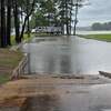
April showers brought lots of headaches to parts of Cherokee County over the weekend.
The National Oceanic and Atmospheric Administration (NOAA)’s National Weather Service (NWS) reported the storm system that moved across the area on Saturday, April 6, brought damaging winds of up to 93 miles an hour; dropped more than 5 inches of rain across the county; and pummeled several areas with softball- or grapefruit-sized hail -- causing chaos and potential insurance claims for some people.
“We lost a tree, But oh, are we blessed,” Gallatin resident Jenni Cudd stated in a post on her Facebook page. “It’s one that was damaged from before we moved in and it needed to be cut down. We’ve been praying that it wouldn’t fall on our house or cars. Today during the wind and rain, it fell away from the house! Now we’ll just cut it up and have firewood for next winter!”
Locally, the NWS reported receiving information about pea- and quarter-size to ping-pong- and golf ball-sized up to two inches in diameter falling in the areas of Maydelle, Jacksonville, Lake Jacksonville, Pierces Chapel and Neches.
“We’re glad there were no injuries and damage was minimal,” Cherokee County Emergency Management Coordinator Sergio Servin said. “We did have some issues with our Code Red system, where people weren’t getting their notifications early enough, but we are working to resolve that issue to make sure everyone is getting the information they need in a timely manner.”
NOAA reports also mention getting pictures of softball sized ice balls, shared with the organization via social media sites by residents of Alto and Grapeland.
“Along with residents and businesses facing car damage, my precinct saw a large number of downed trees, flooding, and several dirt roads were washed out,” Cherokee County Precinct 2 Commissioner Steven Norton said.
Pearman Motor Company in Alto reported Tuesday an estimated 150 vehicles on their lot sustained hail damage.
“Everything that was outside was damaged,” dealership partner JD Pearman said. “And all six of our buildings’ roofs were damaged too. It’s going to a take a good little while to take care of things, but we’re moving forward with it.
“This is actually the first time we’ve ever been hit with something like this. But this is East Texas so it’s just something that’s going to find you sooner or later.”
More than 900 people were still without power early Monday in numerous areas, including Dialville, Whitehouse, Palestine, Athens, Diboll, Kilgore and Henderson.
Also on Monday, the National Weather Service’s Shreveport office on Monday extended the flood warning for the Neches River near Alto, through Sunday, April 14.
“At 9:15 a.m. Monday, the stage was 14.6 feet and expected to rise above flood stage (16 feet) by Tuesday morning and continue to rise to near 16.6 feet by Wednesday early afternoon,” the NWS report states.
“Boat ramps and picnic areas near the river will begin to flood. Ranchers should move cattle and equipment near the river to higher ground.”
While no tornadic activity was reported in Cherokee County, preliminary data point to EF-0 to EF-1 category tornadoes touching down in the areas of Beeville, Arlington Heights and Keenan – damaging an estimated 50 RVs; destroying 12 other RVs, at least one building and a trailer; and snapping numerous trees and light poles in those areas.
Power lines and trees were reported down across roadways in Nacogdoches, Lufkin and Crockett.
Reports of damage followed the storm’s path – from the Galveston and Orange areas all the way through east Texas and into Louisiana, Missouri, Tennessee and even into Illinois and Indiana.
Please support The Cherokeean Herald by subscribing today!


’s...&picture=https://www.thecherokeean.com/rails/active_storage/representations/eyJfcmFpbHMiOnsibWVzc2FnZSI6IkJBaHBBa05DIiwiZXhwIjpudWxsLCJwdXIiOiJibG9iX2lkIn19--48639df3a49b9cd063bec481e81859b27281e48a/eyJfcmFpbHMiOnsibWVzc2FnZSI6IkJBaDdCem9MY21WemFYcGxTU0lOTmpjMWVEUXdNRjRHT2daRlZEb1VZMjl0WW1sdVpWOXZjSFJwYjI1emV3YzZDMlY0ZEdWdWRFa2lERFkzTlhnME1EQUdPd1pVT2d4bmNtRjJhWFI1U1NJTFkyVnVkR1Z5QmpzR1ZBPT0iLCJleHAiOm51bGwsInB1ciI6InZhcmlhdGlvbiJ9fQ==--cb2162d3aacb7cbcb10ba2515b80f10e2da2a22d/aw_hail.jpg)
’s...&media=/rails/active_storage/blobs/eyJfcmFpbHMiOnsibWVzc2FnZSI6IkJBaHBBa05DIiwiZXhwIjpudWxsLCJwdXIiOiJibG9iX2lkIn19--48639df3a49b9cd063bec481e81859b27281e48a/aw_hail.jpg)